Page 1 of 2
Dog Lake / Cranberry Lake
Posted: Thu Dec 12, 2002 9:42 pm
by Fishhawk
Lake Description:
This fishing map is under construction but if you print it off, you'll still be able to use it to prevent yourself from getting lost, and you at least will know where there are some likely looking locations. This map will be updated weekly, or as the flood of info from tight-lipped fishermen permits.
Getting There:
From Ottawa take HWY 7 west to Carleton Place and then take HWY 15 south. Slow your vehicle and boat down to 150 km/h when you hit Seeleys Bay. Look on the right for Brass Point Rd and take it.
From the 401, take HWY 15 north. You've gone too far if you've hit Seeleys Bay - unless you want to get a can of pop and a Mars bar.
Launch:
To launch at Dog Lake, take Brass Point Road to Carrying Place Road, go to the end and launch at Melody Lodge.
To launch at Cranberry Lake, go to Knapp's Brass Point Camping on Burnt Hill Road at Brass Point Bridge. It's a bit of a hike by boat to Dog Lake if you want that lake to be an option.
Have you fished this body of water? If so, tell us how you did and where you had success.
Posted: Mon Jan 05, 2004 2:11 am
by Wall-I-Guy
Top-Water LargeMouth
Posted: Thu Feb 19, 2004 11:14 pm
by LineZinger
My father and I fised the bay in C,6 last year, 2003, the week on july 4th. We through Xero Spooks, and Bagley's Bang-a-Lure's. Best luck was anytime of day that the wind wasn't blowing. Must have caught around 150 just in that cove.
Re: Top-Water LargeMouth
Posted: Thu Feb 19, 2004 11:49 pm
by Wall-I-Guy
LineZinger wrote:My father and I fised the bay in C,6 last year, 2003, the week on july 4th. We through Xero Spooks, and Bagley's Bang-a-Lure's. Best luck was anytime of day that the wind wasn't blowing. Must have caught around 150 just in that cove.
Impressive!
Posted: Sat Mar 13, 2004 12:43 pm
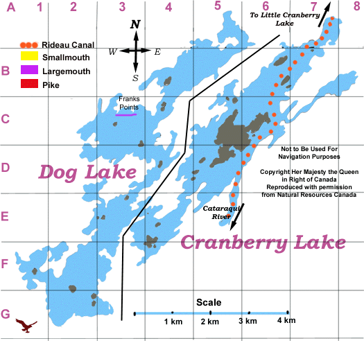
by Rescue78
Please help me out with this map

People keep refering to landmarks on that lake.
Is top of D2 The shipyards with the beach at the corner of C2-D3

Where is fiddler's elbow
I assume the crane's nest is at A5.
Do I read this right?
Rescue 78
Posted: Sat Mar 13, 2004 1:16 pm
by Cancatchbass
The map
is confusing, even to those who know the lake well.

Fiddlers Elbow is in E3, where the black line crosses at approx. 2 o'clock.
Cranesnest
is at A5, though the shape of the lake is not even close.

As for the shipyards- that's Gilmour Point in the bottom right corner of C2. Watch for stumps in that area if you're not familiar with it.
Hope this helps.
CCB
Posted: Wed Mar 24, 2004 9:59 am
by Rescue78
Thanks CCB.
I'm glad I'm not the only having a hard time to use the map.
Hope to see you there this summer.
Posted: Sun Apr 11, 2004 5:57 am
by Wall-I-Guy
Won't be long now, I'll be back for some Laker/Splake action

Gan Lake
Posted: Sat Jan 29, 2005 8:59 am
by Joisey Joe
Great to see Gan Lake in the map section! Here are some hot spots for Pike. The South tip of the Big Isl. is a good spot, it's weedy and they lurk there. Same for the south tip of Pine Isl., was very productive last yr., also try between Birtch Isl. and the channel to Back bay, under the high tension wires, shallow and weedy, nice spot. Also on the way to The Crank you go thru The Narrows, the narrow section on the map before you get to The Crank. Also shallow and weedy, lots Pike there. Husky Jerks and any shiney lure, Mepps Syclops does well there. I had good luck with minnows in all the spots, either on a bobber or bottom bouncers. Good luck, Joe.
Posted: Sat Jan 29, 2005 9:48 am
by SkeeterJohn
Thanks for the report bigjoe.. we'll make sure to add your suggestion to to the map page. Watch out for many more maps appearing over the next few months.
map project Dog and Cranberry Lakes
Posted: Sun Feb 06, 2005 12:08 pm
by Tom Boetefuer
I have been coming to these lakes for the last 10 years, in may, for some pike fishing with a large group out of the Philly area. The maps are great and I have just ordered some on line to use up there. I recently purchased my first boat. I know a lot of the hidden rocks and stumps on Cranberry, But have never really been on dog lake because of the hike in a small rental. I have a concern about hitting anything . Any tips for getting around would greatly be appreciated
Posted: Mon Feb 07, 2005 7:00 pm
by Wall-I-Guy
Hey Tom Boetefuer,
Welcome aboard

I've trolled around Dog Lake for Splakes with no issues at all. I haven't spent much time in the shallows except to catch the Sunfish we use. It's typical as any lake with bays, deadheads and the odd shoal.
I have trolled quite a bit of the shoreline with no issues.
Any Updates?
Posted: Mon May 01, 2006 11:16 am
by mdej
Going to be in the area from Whitefish down to Dog on Victoria Day weekend. Target will be Pike for sure!!!!
Just want to hit some locations that I can fish and not be distrubing the largemouth spawning.
Also, is the Seeley's Bay launch at D6 or B7 on this map?
Dog Lake splake - rental boats
Posted: Tue May 09, 2006 8:33 am
by Dances With Fishes
Hey Tom, by any chance do you stay / rent boats at the Shangrila camp ground at Jones Falls (Whitefish Lake)? If so I am right around the corner from you. Next time you are down on the lake give me a shout and I can give you a relatively quick tour of the area (by water) that will get you where you want to be. I plan to do alot of fishing on Dog / Cranberry Lake(s) this year.
WIG - I wouldn't mind hooking up with you next time you are going out on the Dog.
DWF
Posted: Thu Jun 08, 2006 9:06 pm
by joek
Hi Guys
I've fished Cranberry/Dog since 1982 on and off, and every year since about 1995.
I fish the 4th of July week (2nd week of bass), I stay at Melody Lodge in the cabin that's right on the water, bottom right hand side. Look for the black/gold/ red lettered Pro Craft along side and stop in for a beer.....anyway....First......
The way I'm seeing the map, Fiddlers Elbow is in E4, and if you look, you'll see a little black dot on the map....that's a ROCK that's almost in the middle of the elbow. Sometimes it's marked, usually it's not.
Going from Cranberry to Dog, you have to stay RIGHT. As you come around the first turn, stay right and head like you're going to go straight into the bay, then make the left and head toward the big rock on the right, after you clear the middle of the elbow, start heading left, away from the right shore because theres a rock pile (usually unmarked) about 200 yards or so, on the right after you come out of the elbow.
Your other option, is to, as you come in to the elbow, hug the left shore and pass between the rock and the shore. (I do the first )
BEFORE you do either of these however, GET A MAP, and go thru SLOW, until you learn the way. Both the bays that you pass there are good fishing, most years, depending on the weeds.
Second...the launch at Selleys Bay ISN"T show on this map. When your leaving Cranberry, (top right of map), you have to go through the swing bridge, then follow the channel markers (remember, red right returning) to Seeleys Bay. There are signs (and a speed limit) when you get there. You'll see the channel go left and you'l go right, into Seeleys Bay.
Hope this is some help.
Joe